Water Foundation (WF): Can you start by telling us a little bit about American Rivers and what its mission is in the West?
John Cain (JC): American Rivers is a national river conservation organization that works to protect rivers for fish, wildlife and people. And we are working actively in the northern Rockies, the Southwest along the Colorado River basin, in the Pacific Northwest and in the Sacramento-San Joaquin watershed to find a better balance between human uses of the watershed and the needs to protect rivers. Our programs throughout these areas include an emphasis on protection of wild and scenic rivers in the northern Rockies, balancing consumptive use with water conservation programs and river restoration in the Colorado basin, and an emphasis on salmonid restoration in the Pacific Northwest and the Sacramento-San Joaquin basins.
WF: How long have you been working for American Rivers?
JC: I’ve been working for American Rivers going on 8 years now.
WF: What’s the focus of American Rivers in California and your work in particular?
JC: American Rivers programs span from upper watersheds including meadow restoration, to the foothills including reservoir operation and relicensing of federally licensed dams. In the Central Valley we’re focusing on salmon restoration, flood management, and water rights issues. The focus of my work has been how to integrate flood management and river restoration in the Central Valley and the Delta.
What I often tell people about American Rivers is that when it comes to river management, public safety is the highest priority because there really is no other option. And we believe that the best way to keep people and property safe from flooding is to give rivers more room. Giving rivers more room provides a number of other benefits like groundwater recharge, clean water, open space and recreation, and habitat for fish and wildlife.
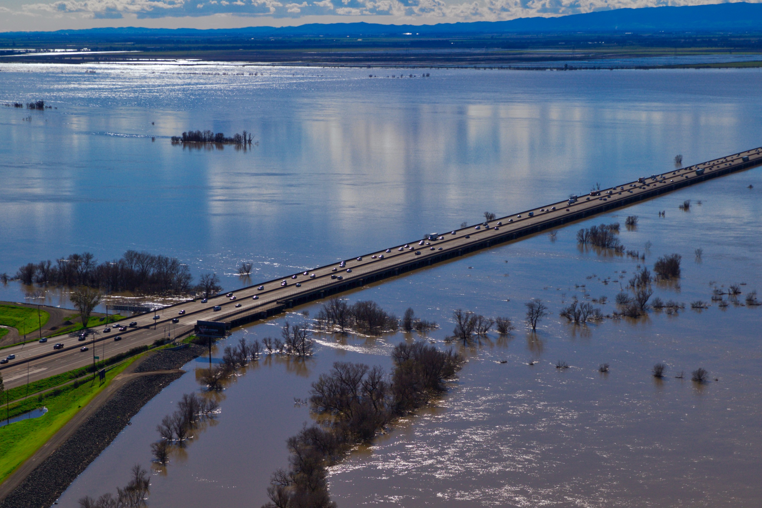
WF: How has flood management changed in California?
JC: Under the old paradigm—a flood control paradigm based on the idea that we have the power to control floods—we were simply focused on controlling the probability of flooding through structures like dams and levees. The new paradigm focuses on managing flood risk, and it starts with limiting development on low-lying flood plains, so we don’t put development right up against rivers in places that are likely to flood, particularly as the climate changes. And it also emphasizes expanding our flood ways so that there is enough room to safely convey flood flows during the large events we expect climate change to bring.
WF: Tell us more about this new paradigm and how it leads to enhancing the California landscape, specifically the Central Valley.
JC: It starts with the notion that is well respected in flood management and flood engineering circles—including at the Army Corps of Engineers—that we need to move away from the idea of flood control and instead we need to focus on flood management. The first step of this approach is making sure we’re not developing urban communities on low-lying floodplains. We need to instead protect the beneficial uses of floodplains so that there’s enough room to safely convey flood flows when floods occur.
Flood risk is the probability of flooding multiplied by the consequences of flooding. In the old paradigm we just focused on controlling the probability of flooding by building levees and dams. The problem is they don’t always work. So a 100-year levee would protect against the 100-year event, but not necessarily against the 105- or 200-year event. And if houses are built behind that levee, the consequences could be catastrophic, like we saw in Hurricane Katrina. And indeed after Katrina, the Corps of Engineers has really focused on this new paradigm of keeping people out of harm’s way as a means of reducing the consequences of flooding, which is the other side of the risk equation.
And now thanks to advocacy of several conservation organizations supported by the Water Foundation, the state of California has also wholeheartedly embraced this flood management paradigm. When we keep development off of floodplains, it opens up the opportunity to intentionally manage the flood plains for a variety of other uses that are consistent with healthy rivers, like groundwater recharge, and fish and wildlife habitat corridors along the river. And this allows us to envision a future where we have healthy, vibrant river corridors bisecting the communities of the Central Valley. We can imagine productive agriculture in the Central Valley with these corridors of healthy habitat that are large enough to convey flood flows.
When we keep development off of floodplains, it opens up the opportunity to intentionally manage the flood plains for a variety of other uses that are consistent with healthy rivers, like groundwater recharge, and fish and wildlife habitat corridors along the river.
WF: Embedded in this new paradigm is an idea of resiliency?
JC: Absolutely. This is particularly important for adaptation strategy for changing climate. And in California there is not a lot of debate about whether the climate is changing. The water districts are all very dependent on snow pack and it’s obvious to see that our snow pack has been shrinking over time. It’s pretty clear from the last extreme drought we had to the very wet winter we’ve had this year that we can expect to see new extremes that climate scientists are telling us will occur with a changing climate.
The 2017 update for the Central Valley flood protection plan included a climate change analysis that’s predicting that the size of the 100-year flood on the San Joaquin and its tributaries will increase by 85 percent. It will nearly double. This is absolutely a huge change in hydrology. And we’ve actually been seeing these changes in real time over the last 20 years. In 1995 the projected 100-year flood on the San Joaquin River was 25,000 cubic feet per second. And it had only recently been increased to that amount. Prior to the 1986 floods they estimated the 100-year flood at 15,000 cfs. In 1997, 70,000 cfs flowed down the river. Nearly three times the projected 100-year event. Now we’re expecting that number to double again for a 100-year event.
WF: This really does seem to call for a change in how we think and manage these systems.
JC: It does. On the San Joaquin in particular, the levee system was built to convey the pre-climate change, mid-19th Century, 50-year event. And now because the levee system hasn’t been well maintained and because we know that larger events occur, it’s really only adequate to convey the 20-year flood in many locations.
WF: How do you move forward? Has the Water Foundation’s support been helpful?
JC: The Water Foundation has been critical to our advancement of our work over the last 8 years. They helped us put together and supported a coalition of environmental groups that are meeting every week to develop a common vision and strategy for transforming flood management in the state. This group includes hunting and fishing groups, along with more traditional environmental groups, and we have able to effectively speak with one voice about how to change flood management, with a real emphasis on creating multi-benefit flood risk reduction projects. These are projects that are designed to reduce flood risk but at the same time improve water quality, increase groundwater recharge, and enhance habitat for fish and wildlife.
And we don’t always necessarily agree, but at least we have this forum for communicating efficiently so that we better understand how we can most effectively move forward. Increasingly this regular communication has allowed us to be developing and executing common strategies for improving river and water management in the Bay-Delta watershed.
We wouldn’t have this level of coordination if it weren’t for the Water Foundation’s support and strategic thinking about how to best support the conservation and water management community.
WF: Shifting gears, tell us about a specific project you’re working on that you’re excited about.
JC: At American Rivers we’re very interested in working with other groups like Sustainable Conservation and the Nature Conservancy to figure out how to achieve the purposes of groundwater recharge, river restoration, and flood risk reduction all in the same space along a river corridor. And again, this not only has this groundwater and flood risk reduction benefit and habitat benefit, it also creates a great opportunity for recreation and open space in the Central Valley, in an area where there are many economically disadvantaged communities, that have limited access to the river today and would benefit from more recreational opportunities along the river.
We have one exciting project in the communities of Firebaugh and Mendota on the San Joaquin River to improve flood protection for the community of Firebaugh, integrate it with the San Joaquin River restoration, improve groundwater recharge, and create a recreation trail that links Firebaugh to Mendota, one of the most economically disadvantaged communities in all of California.
WF: A multi-benefit project.
JC: Exactly.
WF: And would that be a floodplain restoration project? What does that involve?
JC: It involves acquiring flood easements from farmers along the river that have local levees, breaching those levees to allow the river to flow over those properties during floods and lower the flood risk for the community of Firebaugh.
WF: And farmers are still able to farm on those lands?
JC: In some cases some of those farmers would still be able to farm, in other cases they might be willing to sell the land outright for habitat restoration. The possibility varies depending on the specific pieces of land and their elevation relative to the river.
WF: Is it similar situation in other parts of the state?
JC: Yes. The Yolo Bypass west of Sacramento provides an example of where floodplain restoration is consistent with continued agriculture. And as you know there is very productive agriculture lands in the Yolo Bypass and it floods two out of three years.
One of the things that we discovered in our work on the lower San Joaquin River is that even if you remove the levees, the neighboring agricultural land can be productive because it doesn’t get wet every year. In fact, in the case of Paradise Cut [a project to expand an existing bypass near Lathrop, CA], the farmlands that would be added to the flood bypass would only get inundated once every 12 years during the extreme flood events. But this new bypass creates a safety valve that allows floodwaters to go somewhere during extreme events and removes the constraints associated with managing the river during the rest of the time.
So by having these new flood bypasses, you can continue to have agriculture along the river in the new flood bypasses and you have more flexibility in managing the river for ecological purposes. You also have more flexibility in managing upstream reservoirs for the sometimes-conflicting purposes of water supply and flood control. With new analysis we’ve been able to show our agricultural partners that expanding floodways and flood bypasses is consistent with conserving agriculture at the same time as reducing flood risk and restoring habitat.
WF: John, we could talk a lot more, but we’ll have to wrap up here. Thank you so much for your time.
JC: Thank you.
This interview has been edited and condensed for clarity.